10 Earth impact craters you must see
Visit these Earth impact craters, even from the comfort of your own home.
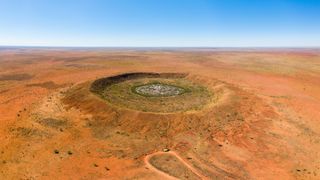
Planet Earth holds some of the strangest, natural tourist destinations in the solar system.
Earth is perpetually bombarded with debris from outer space. Luckily for us, most of it burns up during entry through our atmosphere and we enjoy this bright burn in the night sky in the form of fleeting meteor showers.
But on occasion, an object is so big it survives its entry through the atmosphere and it leaves its mark on the planet, literally. According to the Lunar and Planetary Institute, impact craters are formed when a planet's surface is struck by a meteoroid, leading to the excavation of the surface material. These impact structures are characteristically roughly circular, excavated holes.
According to the Planetary and Space Science Centre (PASSC) at the University of New Brunswick in Canada, there are 190 confirmed impact structures on Earth. Each is recorded in their database — a collection of images and publications on impact structures around the world that has been compiled over the last 25 years. Despite our planet's habit of erasing these cosmic footprints, there are myriad craters still visible on Earth. Now, you can explore these incredible features yourself, both in real life or from the comfort of your own home via Google Earth.
Related: How are asteroids, space weather and space debris detected before they hit Earth?
Due to Earth's dynamic climate, processes such as weathering and erosion work to erase any trace of these cosmic visitors from our landscape. Some of the largest impacts ever to occur on Earth are barely visible to us today (at least not in the traditional 'hole in the ground' sense.)
In South Africa, the Vredefort Crater, also known as the Vredefort Dome is the world's largest known impact crater, according to NASA Earth Observatory. Scientists believe the impact forged a crater between 111 and 186 miles (180 and 300 kilometers) wide, but as the crater has endured over 2 billion years of erosion, its exact size is difficult to determine.
Impact craters are our window into Earth's geological past. Scientists study these structures to understand the history of our dynamic solar system and use this information to predict future impact scenarios.
1. Barringer Crater
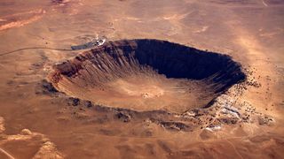
– Location: Arizona, U.S
– Diameter: 0.8 miles (1,300 meters)
– Depth: 570 feet (174 meters)
– Age: 50,000 years
Barringer Crater, also known as Meteor Crater, formed relatively recently (geologically speaking) just 50,000 years ago when a large iron meteor measuring 98-feet (30-meter) to 164-feet (50-meter) in diameter, crashed into the Colorado Plateau in northern Arizona, according to the Lunar and Planetary Institute.
The 300,000-ton meteor was traveling at speeds of up to 26,000 miles per hour (12 km per second), according to the Barringer Crater Company, and exploded with the force of two and a half million tons of TNT, the impact excavated a whopping 175 million tons of rock according to the Lunar and Planetary Institute.
The crater's origins were first identified by mining engineer Daniel Moreau Barringer who was convinced the crater was a result of a meteor striking Earth, a view that was not shared by many scientists at the time. Despite the opposition, Barringer spent several years investigating the crater and providing the first proof of its origin, which was eventually vindicated and accepted by the scientific community.
However, Barringer's interest in the crater was not solely driven by his urge for scientific understanding. He believed that a huge meteorite lay beneath the crater and that it could be mined for its valuable metal content. He spent the rest of his life attempting to mine the crater, but his efforts were in vain as a majority of the meteorite would have been destroyed on impact according to the American Museum of Natural History.
The crater is privately owned by the Barringer Crater Company — a family-owned enterprise dedicated to the preservation of the crater. The company was founded by Daniel Moreau Baringer, the first to identify the crater's cosmic origin.
Nowadays, the Barringer Meteor Company aims to preserve the crater and ensure appropriate access by the public via the Meteor Crater and Barringer Space Museum visitor center.
2. Lonar Crater
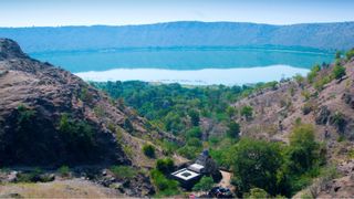
– Location: Maharashtra, India
– Diameter: 6,000 feet (1,830 meters)
– Depth: 500 feet (150 meters)
– Age: 35,000 to 50,000 years
Nestled inside the Deccan Plateau in Southern India, lies Lonar Crater, a large meteorite crater that has baffled scientists since it was identified in 1823 by British officer C.J.E Alexander, according to NASA Earth Observatory.
The crater is located within a huge plain of basaltic rock left over from volcanic eruptions in the region 65 million years ago. As such, the crater was originally thought to be a volcanic crater. Nowadays it is known that the crater formed between 35,000 and 50,000 years ago as a result of a meteor impact.
Lonar Crater is the only known impact crater to have formed in basalt, according to the British Library. The unique ecosystem is a haven for local flora and fauna, the low crater hills are covered with trees and home to several species of wildlife including peafowl, chinkara and gazelles, according to India's news website India.com. Migratory birds can also be spotted flocking to the lake during the winter months.
The crater site is also of great cultural significance and features in Hindu mythology. According to National Geographic Traveller, Lonar Lake is considered to be the place where Lord Vishnu slayed the demon-giant Lonasura and, as part of they mythology, the crater was the demon's lair and the lake was a result of its spilled blood.
This cultural importance is echoed by the temples — built around the 12th Century — found around the crater's edge, according to the British Library. Whilst most of the temples now lay in ruin, one temple dedicated to the local Goddess Kamalaja Devi is still used for active worship, according to the India history website livehistoryindia.com.
Scientists flock to Lonar Lake not only to study the unique basalt-based crater but also the lake itself which is both saline and alkaline. In June 2020, Lonar Lake surprised scientists and locals alike when it turned a rosy pink. According to the Indian news website thehindu.com, the striking color change was most likely caused by a large population of salt-loving microscopic organisms called Haloarchaea, or halophilic archaea, that produce a distinct pink pigment. The elaborate transformation was short-lived as by July 2020 the lake had reverted to its original form.
3. Wolfe Creek Crater
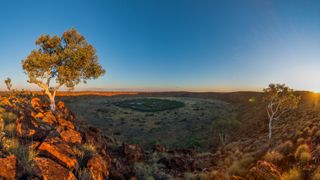
– Location: Western Australia
– Diameter: 2890 ft (880 meters)
– Depth: 196 ft (60 meters)
– Age: 120,000 to 300,000 years
Wolfe Creek Crater is positioned on the edge of the Great Sandy Desert in the Wolfe Creek Crater National Park, northern Western Australia.
According to the Australian Parks and Wildlife Service, Wolfe Creek Crater formed 300,000 years ago, though, a recent study from the University of Wollongong in 2019 analyzed the radiation exposure of the crater rocks and placed an estimated age on the crater of just 120,000 years, far younger than previous estimates.
A prominent feature of the landscape, Wolfe Creek is the "second-largest crater in the world from which fragments of a meteorite have been collected" states the Australian Parks and Wildlife Service. Scientists estimate that the crater's meteor, which was 50 ft (15 meters) in diameter and weighed over 15,000 tons, was probably traveling at eye-watering speeds of 10 miles (17 km) per second before slamming into the Australian desert.
According to the Australian Parks and Wildlife Service, the crater wasn't spotted by Europeans until 1947 when it was observed during an aerial survey of the region. However, according to the travel site Australia's northwest, Wolfe Creek has long been known to Aboriginal people and is known as Janyil in the aboriginal language Jaru and as Karntimarlarl in the aboriginal language Walmajarri.
According to the Australian Parks and Wildlife Service, there are many cultural stories associated with the crater amongst local, indigenous communities. One story involves two giant ancestral snakes who formed the nearby Sturt and Wolfe Creeks when they made their way across the desert. The crater is where one of the mythological snakes emerged from the ground according to the story.
The crater lies 90 miles (145 km) from the nearest town, Halls Creek. This isolation has helped preserve the crater and surrounding area and according to Australia's northwest, Wolfe Creek Crater was given class A reserve status in 1979, adding further protection to this astonishing landmark.
The public is encouraged to visit the crater during the dry season (May to October) as access to the site is via a gravel road and is not appropriate for unconventional vehicles. There is a 1,312-foot (400-meter) return walk to the crater rim which involves a steep rocky climb and climbing down into the crater is forbidden due to loose rocks making it dangerous. Wolfe Creek Crater is home to some interesting wildlife including the vocal Major Mitchell's cockatoo harvesting seeds from plants on the crater floor and brown ringtail dragon lizards on the hunt for insects, according to the Australian Parks and Wildlife Service.
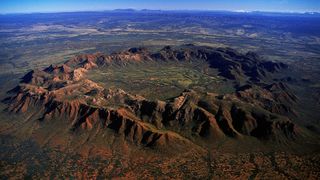
4. Gosses Bluff (Tnorala)
– Location: Northern Territory, Australia
– Diameter: Originally around 13.6 miles (22 km), now 2.7 miles (4.5 km)
– Depth: Originally 3 miles (5 km)
– Age: 142 million years
Australia is home to some of the most impressive impact craters in the world, so it comes as no surprise that we feature yet another Australian crater in this "must-see" list.
Gosses Bluff, also known as Tnorala is of great cultural and scientific importance and is the most heavily studied impact crater in Australia, according to NASA Earth Observatory. Sandwiched between the Macdonnell Range and James Range in the heart of Australia, those wishing to access the crater must respect the cultural importance of the site to the Western Arrernte Aboriginal people and obey signs stating where access is not allowed, according to the Australian Government.
Scientists believe that a meteor traveling at speeds of up to 25 miles per second (40 km per second) slammed into Earth 142 million years ago, creating a giant crater nearly 14 miles (22 km) wide according to NASA Earth Observatory. While the original crater has been eroded over the years, the core of the crater, a central ring of hills almost 3 miles (4.5 km) in diameter, is still visible to this day. According to the Australian Government, the remnant crater was given the name Gosses Range by the explorer Ernest Giles in 1872. He named the crater after H Gossem, a Fellow of the Royal Society.
The Tnorala conservation reserve is a registered sacred site. As such, the Western Arrernte Aboriginal people welcome visitors to experience Tnorala but ask those visiting to exhibit respect for the area and walking on the crater rim is forbidden, according to the Australian Government.
According to the Parks and Wildlife Commission of the Northern Territory, Aboriginal tellings of the crater's origins are similar to those of scientists in that they both have celestial origins. A Western Arrernte story reveals that Tnorala was formed when a group of women danced across the sky as the Milky Way, during the dance a mother put down her baby to rest in a carrier. The carrier fell over and crashed to Earth where it became the circular rock walls of Tnorala.
Whilst the reserve is accessible all year round, travel during the cooler months (April to September) is advised. The reserve lies approximately 108 miles (175 km) from Alice Springs and access with a vehicle with four-wheel drive is recommended, according to the Parks and Wildlife Commission of the Northern Territory.
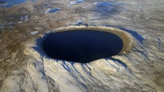
5. Pingualuit Crater
– Location: Pingualuit National Park, Quebec, Canada
– Diameter: 2.1 miles (3.4 km)
– Depth: 876 feet (267 meters)
– Age: 1.4 million years
The Pingualuit National Park is situated in the heart of the Ungava plateau and is home to the impressive Pingualuit crater.
Under the arctic sky, the crater is filled with pristine rainwater, cut off from inflows from other lakes. This unique environment — 876 feet (267 meters) deep — provides scientists with a window into the geological past. According to NASA Earth Observatory, sediments of Pinguluit lake were untouched during the Pleistocene Ice Age — a time period that began about 2.6 million years ago and lasted until about 11,700 years ago. While other sediments in surrounding water bodies do not extend further back than the last ice age, those found in the Pinguluit crater have preserved a much longer record.
The crater was first observed from the air in 1943 when the crew of a United States Air Force plane flew over the impact site, according to NASA Earth Observatory. Expeditions did not commence until the 1950s due to the remoteness of the crater. However, there is evidence that that crater site has long been known to the local Nunamiuts — nomadic Inuit who lived on resources of the interior of the Ungava lands according to the national park website Nunavik Parks.
There are traces of rock shelters and stones arranged in a circular arrangement — evidence of where old tents would have been erected according to Nunavik Parks. The traces suggest the Nunamiuts once set up camps on the ridges of the Pingualuit crater whilst scouting for promising hunting grounds.
According to Canadian outdoor media brand explore, in the Inuit language Inuktitut, the Pingualuit region is known as nunavingmi pikkuminartuq which means "a remarkable location where a person may come to be revitalized".
Once only accessible to the Nunamiuts and the hardiest of explorers, nowadays anyone with a sense of adventure can enjoy a trip to Pingualuit crater. Depending on the time of year of your visit you can enjoy a range of activities in the Pingualuit National Park, including hiking in the summer and cross country skiing in the winter and there is a range of tours available via the Nunavik Parks site.
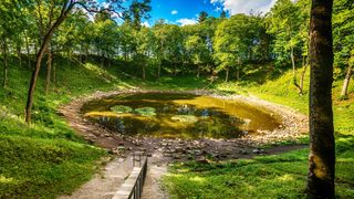
6. Kaali Crater Field
– Location: Kaali, Estonia
– Diameter: Largest crater 360 ft (110 meters)
– Depth: Largest crater 72 ft (22 meters)
– Age: Estimates ranging from 8400 to 2420 years old
Why visit one crater when you can visit nine? Located on Saaremaa, Estonia's largest island, the Kaali crater field lies 11 miles (18 km) from the island capital which consists of one large crater and eight smaller craters according to the news site The Baltic Times.
Remarkably, the island is thought to have already been inhabited at the time of the meteorite impact approximately 1530-1549 BCE according to a study published in Meteoritics and Planetary Science, though the age is still a matter of debate and estimates range from 2,420 years to 8,400 years old. Despite the impact occurring during a time of possible human habitation, according to scientists involved in the study, there is no evidence that the encounter significantly affected a human population in Saaremaa.
Nevertheless, the event would have been quite the spectacle when the meteor broke apart into fragments when it was just 3 to 6 miles (5 to 10 km) above the ground. The pieces then smashed into the Estonian island creating some of Earth's youngest giant craters according to the tourist website Visit Estonia.
Domestic animal bones have been found at the site, and a large stone wall was built around Lake Kaali around the beginning of the Common Era which suggests the area was once used as a sacrificial site, according to Visit Estonia.
The scientific and cultural significance of the Kaali crater field can be explored in greater detail at the Kaali Meteoritics and Limestone Museum. Here you can also view various fossils on display and learn about other discoveries made on the island of Saaremaa. A guide service is available in Estonian, English, Finnish and Russian and there is also a gift shop.
7. Nördlinger Ries

– Location: Western Bavaria, Germany
– Diameter: 16 miles (26 km)
– Depth: 660 feet (200 meters)
– Age: 15 million years
Remarkably, the Ries crater contains a town within its inner ring, a town known as Nördlingen, according to the Planetary Science Institute. The full impact of the crater can only be seen when viewed from the air. Whilst its inner ring is highlighted by the town walls, the rest of the crater has been eroded away and is not immediately visible.
According to NASA Earth Observatory, the crater's existence probably eluded medieval Europeans who unknowingly matched their town walls to the inner crater ring approximately 0.6 miles (1 kilometer) in diameter — likely the same dimensions of the crater-forming meteorite.
According to the Planetary Science Institute, the true origins of the crater also eluded residents of Nördlingen as It was long believed that the Ries structure was an extinct volcanic crater, but when geologists Eugene Shoemaker and Edward Chao visited the town in the 1960s they found overwhelming evidence that Ries was in fact an impact crater.
According to ESA, the meteor was traveling over 43,000 mph (70,000 km per hour) when it hit the ground, exposing the surrounding rock to phenomenal pressure and heat over 45,000 degrees Fahrenheit (25,000 degrees Celsius). These extreme conditions created microscopic diamonds — the largest just 0.2mm — within the suevite rock which was used to build most of the town. Suevite is a type of rock created during impact events where rock is heated during the initial impact and then cooled, leading to fragments of rock and minerals, according to the Planetary Science Institute. As such, this quaint little German town finds itself awash with tiny diamonds — approximately 72,000 tons of them according to an article published by the BBC.
The unique geology of the town even caught the attention of NASA. In August 1970, NASA carried out geological field trips and training in the Ries crater for Apollo 14 and Apollo 17 astronauts so that they could familiarize themselves with particular rock types that are associated with impact craters, which would later help them with their retrieval of rock samples from craters on the moon, according to the Geopark Ries site.
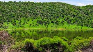
8. Tswaing Crater
– Location: Gauteng, South Africa
– Diameter: 0.8 miles (1.4 km)
– Depth: 650 feet (200 meters)
– Age: 220,000 years
Approximately 25 miles (40 km) northwest of Pretoria, within the area of the City of Tshwane, is the Tswaing meteorite crater — originally known as Pretoria Saltpan (or Zoutpan), according to the City of Tshwane government site. Tswaing is one of the best-preserved craters in the world and sediment deposits from the crater floor contain 220,000 years of climate records.
Visitors to the site can enjoy a 4.4 mile (7.2km) Tswaing Crater Trail as well as a museum display and enjoy the diverse wildlife that resides in the conservation area according to the City of Tshwane government site.
9. Tenoumer Crater
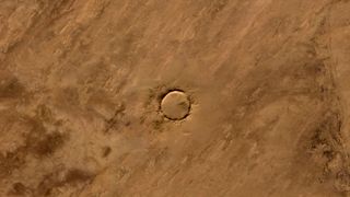
– Location: Mauritania
– Diameter: 1.2 miles (1.9 km)
– Depth: 330 feet (100 meters)
– Age: 10,000 to 30,000 years
Deep in the Sahara Desert is a near-perfect circular crater called Tenoumer. According to NASA Earth Observatory, the origins of the crater had long been debated amongst geologists, with some arguing that it was the remnants of a volcano, it is not agreed that Tenoumer is indeed an impact crater.
Tenoumer is one of the trickiest crater sites to visit due to its remote location. From the Mauritanian capital Nouakchott it's an 11-hour drive to the nearest town of Zouérat, which is about 124 miles (200 km) away.
10. Roter Kamm Crater
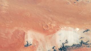
– Location: Tsau ǁKhaeb National Park, southwest Namibia
– Diameter: 1.5 miles (2.5 km)
– Depth: 426 feet (130 meters)
– Age: 5 million years
Amid the rusty-red dunes of the Namib Desert in southwest Namibia is a crater that looks like it'd be right at home on Mars. According to ESA, the Roter Kamm crater is found in the Tsau ǁKhaeb National Park (also known as the Sperrgebiet), a mining area in southwest Namibia. Scientists believe that the meteorite that formed this crater five million years ago was the size of a large vehicle when it collided with Earth, according to ESA.
The impact gave rise to a crater rim 131 to 295 feet (40 to 90 meters) above the surrounding plains whilst the crater floor is blanketed in sand deposits at least 330 feet (100 meters) thick.
You can follow Daisy Dobrijevic on Twitter at @DaisyDobrijevic. Follow us on Twitter @Spacedotcom and on Facebook.
Join our Space Forums to keep talking space on the latest missions, night sky and more! And if you have a news tip, correction or comment, let us know at: community@space.com.
Get the Space.com Newsletter
Breaking space news, the latest updates on rocket launches, skywatching events and more!

Daisy Dobrijevic joined Space.com in February 2022 having previously worked for our sister publication All About Space magazine as a staff writer. Before joining us, Daisy completed an editorial internship with the BBC Sky at Night Magazine and worked at the National Space Centre in Leicester, U.K., where she enjoyed communicating space science to the public. In 2021, Daisy completed a PhD in plant physiology and also holds a Master's in Environmental Science, she is currently based in Nottingham, U.K. Daisy is passionate about all things space, with a penchant for solar activity and space weather. She has a strong interest in astrotourism and loves nothing more than a good northern lights chase!
